Cahaba Mines
The survey for the proposed South and North Railroad was completed in 1858, but construction was delayed by the Civil War. The War put a sharp focus on the need for the manufacture of iron for armament and ordinance. The South was not industrialized and the fledgling iron industry in Alabama was made of small charcoal furnaces located in remote sites and dependent on wagons and carts to move iron to Selma's arsenal.
Thus the War put an emphasis on transportation in order to improve the ability to arm the Confederacy -- providing access to raw materials, bringing these materials to furnaces, and then getting the newly made iron to Selma.
Coal was a key element in advancing the iron industry from charcoal to coke as a fuel for making iron. The process of locating the rail line identified locations where, if coal was available, then transportation would eventually be made available. Getting to the Jones Valley area where the future city of Birmingham would be located required crossing Shades Mountain, but the Cahaba Coal Field was located south of Shades Mountain. The rail line was slated to pass Shades Mountain at Brock's Gap, but the construction required was a massive undertaking.
Prior to the founding of Birmingham in 1871 there were very few coal mines in Jefferson County -- the coal fields were known to exist, but the means of transportation was not available. A major obstacle to the railroad from the south was Shades Mountain, and from the west, financing after the ruin of the Civil War. Coal mines had been developed around Montevallo, and the Alabama and Tennessee River rail line was already there. If the new rail line could be extended north from the vicinity of Montevallo, and new mines could be opened along the rail line, then additional development could follow, and could help to generate traffic for the new rail line.
The Cahaba Coal Field was developed and ready to provide coal for making arms to the Confederacy during the war . The Alabama and Tennessee River Railroad, later the Selma, Rome and Dalton extended northward from Selma, Alabama to Montevallo, the site of coal mining since before the War. From Montevallo, the railroad came eastward to Limekiln, later to be the town of Calera. If the railroad could be extended north from this location then additional coal resources could be tapped.
The Central Alabama Railroad, later to be the South and North Alabama was to extend from Montgomery, Alabama northward to "Limekiln", and then northward to Elyton, which was then the county seat of Jefferson County. During the Civil War, there were tracks from Limekiln to Helena north to the Cahaba River, apparently crossing the Cahaba and stopping at the foot of Shades Mountain.
It was in this area, north of Helena that coal mines began to open in order to take advantage of the presence of the railroad. David Bright's website, Confederate Railroads, http://www.csa-railroads.com/ provides information on Civil War railroads in the south. One of his references is Robert Black's "Railroads of the Confederacy", published in 1952 by University of North Carolina. On the website, Bright indicates the following stations along the South and North Alabama:
| South & North Alabama Stations |  |
|
| Stations |
Distance |
|
Calera (Lime Kiln) |
Located on the Alabama and Tn. River RR |
|
Elliottsville |
6 | |
Flora |
10 | |
Hillsboro (absorbed by Helena Station about 1870) |
13 | |
Oxmoor (located north of Shades Creek along route shown on map) |
24 | |
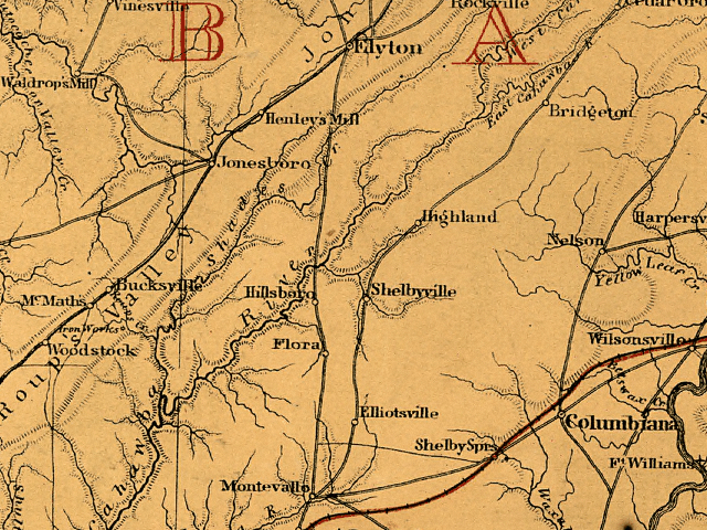
In the 1865 map above (LOC,G3980 1865 .L5 CW 259.5), Limekiln [Calera] would be about half way between Montevallo and Shelby Springs, along the railroad. Oxmoor would be located north of Hillsboro, and South of Elyton. It is interesting to note that this map, although produced by the United States government, shows no indication of Oxmoor. On the other hand, Oxmoor, would have been somewhat of a "secret" if the South had their way. There is an "iron works" noted on Roupes Creek, south of Bucksville. This would later be known as Roupes Iron Works, or Tannehill.