L&N Cane Creek Branch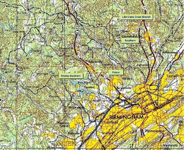
This map shows how the routes developed in the west Jefferson, east Walker County areas. This map shows the story at its end, rather than the beginning, and it was "done" by about 1910. There are some branch lines not shown.
In the map to the right, the L&N Cane Creek Branch follows the north side of the corridor, from the vicinity of Gardendale, to the northwest, then curves around to the southwest along the Jefferson-Walker County line. The Southern (Norfolk Southern today) main line follows a parallel route, southwest of Cane Creek and the Frisco is parallel to the Southern, further to the southwest.
If you look further to the southwest, you see the line that the Ensley Southern interests never completed. It winds from the Fairfield area, near the B in Birmingham, through Edgewater, to Port Birmingham. The "other end" of the line comes from Parrish, partly visible on the west edge of the map, near the upper right corner, and extends to the southeast serving the power plant at Gorgas, AL, on the river. The Ensley Southern did cross the river at Port Birmingham to serve mines at Maxine, in 1908 (Mele, p. 46), but never connected to the line from Parrish. The line to Maxine was removed years ago, but that is another story.
Cane Creek Branch
As soon as the "stand alone" L&N line was extended and opened initially in 1903, additional development of coal mines continued in competition with the Southern and the Frisco predecessor lines.
The following map study shows the area. Starting at the Black Creek Junction on the main line north of Birmingham, the maps follow the line to the west. Initial images are from 1906 USGS maps, and then 1938 USGS maps. These images were taken from the University of Alabama map archive which is linked on this site.
It is noted that the Mary Lee Railroad apparently had trackage rights over the Cane Creek Branch of the L&N. You can go to the Mary Lee RR portion of this site to learn more. I could use help to clarify the locations at which ownership changed.