Mary
Lee Mines
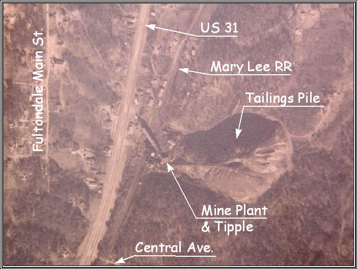
1950 Aerial Photo
This is a 1950 aerial photo showing another mine, located at Fultondale, along the Mary Lee RR. It was known as Lewisburg No. 2 and operated into the 1950's apparently. Keep going on this track to see an earlier photo of this site showing details.
There is a structural "ruin" at this location (2003), that is most likely the foundation of the coal washer.
Consider This
From time to time it has been found that the USGS maps from around the turn of the century can be very inaccurate.
Note that in the 3 older maps, prior to 1906, the Mary Lee RR is shown with a line to the north and to the south. The 1906 map does not show this line to the north.
County Highway maps dated 1937 & 1942 do not show a rail line going to the north along US 31, north of Five Mile Creek. But, in 1960 maps, a line to the north is shown on the County Highway map. This 1950 (certain) photo shows the rail line extending north of Lewisburg No. 2.
The 1935 district rail map, which got this web site started in the first place does not show a line to the north from the mine site. The 1937 photo from the LOC shows the rail line in the background at least as far as Lewisburg No. 2.
Bob Irvin's comments on operations elsewhere in this web site imply that the connection was there in 1954.
1959 USGS maps show the line going north and connecting to the Cane Creek Branch.
Another map in the author's collection, dated about 1960, shows the Mary Lee line going north from the split at Five Mile Creek and clearly connecting with the Cane Creek Branch of the L&N.
So, one conclusion is that there has been a north line from the beginning, as shown on the early maps, prior to 1906. If that line didn't connect all the way to Cane Creek Branch then maybe it was considered a spur line and was not mapped, by agencies like the Highway Department.
So, between 1942 and 1950, was the line extended north to connect to the Cane Creek Branch? Clearly it was there in 1950, as shown in the aerials. So, this would limit the date of the extension to possibly between 1942 (Highway Dept) and 1950 (aerial photo)? Anyone have the answer?