Along the "Old Line" of the L&N, north of Birmingham
Bar-B-Que and the Warrior
Mineral RR
I
moved to Birmingham in 1992 from
Nashville and was immediately struck by
the clear historical presence of so many
railroads.
Being from Nashville, I was sort
of an L&N fan, but Nashville was
sort of a “one railroad town”.
I
learned that Bar-B-Que plays an
important role in the day to day life of
folks in Alabama, along with church and
uh, football.
I did a lot of work in my career
for the Highway Department and soon
heard about the Top Hat Bar-B-Que in the
south end of Blount County.
So, not long after I moved I had
a chance to be in that area and stopped
in for a late lunch.
The
Top Hat wasn’t busy that day, and I
got to talking to the “pit man”.
You know that you have to get up
pretty early to start a day’s run of
butts and shoulders.
Some mornings he told me, he
would be working alone, very early.
“It’s the strangest thing”,
he said, “but some mornings, real
early, I’d swear that I hear an old
time steam engine goin’ by – right
by, close – you know?
And I hear that old steam whistle
just talking…”
He finished up with “I just
hears it sometimes, not all times –
sure do sound lonesome…”
Sometimes where I live, I can hear the CSX trains on the mainline not so far from my house and I would swear that the diesel horn was a steam whistle… I understand the Pit Man’s story.
 |
|
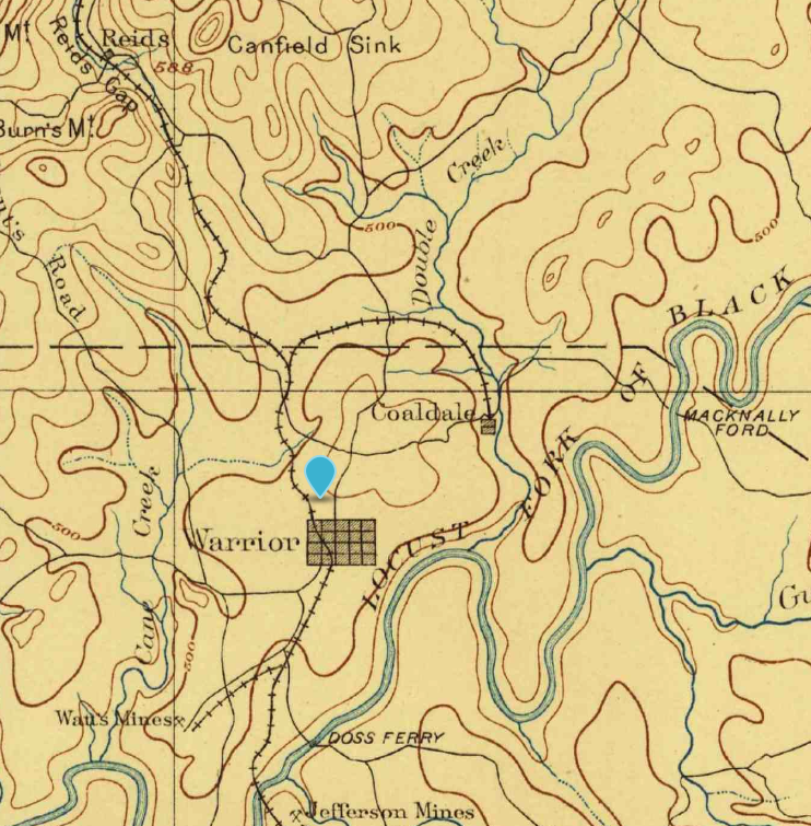
1889 USGS map from USGS Topo View website. |
A
while back, Marv Clemons, James Lowery
and the author took a field trip to the
Helena Museum to talk with Ken Penhale
about railroad history in the area.
Ken’s people came from the
mines in Cornwall to the mines in Helena
in the 1870’s.
That goes back to the roots of
Birmingham’s industrial and railroad
history.
Helena was near the end of track
through the end of the Civil War.
Coal mined near Helena, was
brought on a spur to the interim
mainline of what became the South and
North Alabama’s mainline to Birmingham
– after the War.
From
Helena, the coal was taken south to the
Alabama and Tennessee River Railroad,
later the Selma, Rome and Dalton, and
shipped to Selma for use in the
foundries there.
When the Eureka Company was
formed (at Oxmoor furnace) to experiment
with making iron using coke instead of
charcoal, the coal came from Helena
mines.
Upon the success of the
experiment in 1876, a hundred coke ovens
were built at Helena – the ruins are
still there, adjacent to the
Hillsborough Subdivision.
And there are other old ovens
nearby on Buck Creek – Ken Penhale
knows all about the area.
Go visit the museum at Helena!
At
the time of the Eureka experiment,
carried out at Oxmoor Furnace,
Birmingham was hardly even born.
There had been a financial “panic”
in 1873, and the newly built railroad
struggled for lack of freight much less
passengers.
As Ethel Armes says in her
landmark history “The Story of Coal
and Iron in Alabama”, no one traveled
much in Alabama in those days.
And there was little capital for
mines.
She
also tells us that at this time, there
were only a few coal mines opened in the
area that became the Birmingham
District.
The mines at Helena, some of
which dated before the War, were located
in the Cahaba Coal Field.
The other mines, brand new at the
time, were also tried for coking coal.
But these mines were far to the
north around the Jefferson and Blount
County line.
That was called the Browne coal
seam of the Warrior Basin, later changed
to the Pratt Seam.
When
the South & North Alabama Railroad
was completed north of what was to be
Birmingham, toward Decatur, the railroad
was in dire financial shape.
In fact the founding of
Birmingham hung in the balance in 1871
because the new company couldn’t raise
the money to pay interest on the State
backed bonds.
A competing railroad, the
Southwest and Northeast, wanted to ship
the area’s mineral wealth to
Chattanooga.
Just in the nick of time, a man
named James Sloss stepped in and offered
a deal to the L&N Railroad which had
been extended south to Nashville.
Sloss offered his Nashville &
Decatur line, and urged the S&NA
backers to offer their line, still
incomplete, to the L&N as a “lease
and build” deal.
The
short version of this story is that the
deal was worked out in Louisville,
finally, and the L&N stepped in to
provide capital to pay the interest on
the bonds, and o provide for the
completion of the line from Elyton,
Birmingham’s predecessor to Decatur.
This was a win-win-win for all
involved as it provided a logical
extension of the L&N toward the
Gulf, saved the S&NA and allowed
James Sloss to move toward a Birmingham
where he entered the iron business.
That is another story.
But,
since the finances were so constrained,
the S&NA’s Chief Engineer, John
Milner, who knew better, had no choice
but to direct the contractor “more
curves, more curves, more stiff grade”
as the line was built north in the hills
and valley of Jefferson and Blount
County toward Decatur.
So, every effort was made to
avoid cuts and fills, to avoid tunnels
and to minimize bridges.
But the line was completed in
1872 and traffic, as little as there
was, could move from Montgomery to
Nashville with the L&N as lease
holder of what was called the S&NA
Division for many years.
But the line and grade were
rough!
So,
in the latter years of the 19th
Century Birmingham slowly started to
become the workshop town envisioned by
its founders who were also the leaders
of the S&NA.
The S&NA’s mainline soon
had new spurs being extended to serve
mining efforts of the pioneer coal
entrepreneurs.
This included mines in the area
whose towns became Warrior, Kimberly and
Morris as well as colorful names like
Majestic and New Castle to name a few.
One of the things that the L&N did showed wise business acumen by its leader, Milton Smith. Smith was willing to support the extension of lines to mining areas. Different arrangements could be worked out, but a typical approach was for the L&N to “lend” the hardware to build the rail spur, as well as capital to pay for grading and draining the new line. At the time, the 1890’s and early 1900’s terms might be 6-7% interest for the mining company and the interim use of adequate hardware from the railroad.
It is noted that subsequently, and about the time period of the story below (c. 1911-1915), the L&N determined the need to "fix" problems with alignment and grade around Birmingham and all the way to Nashville, as well as double tracking this line, due to the heavy traffic that had developed due to Birmingham's significant growth. That work is a story in itself.
Herein
lies the real subject of this story –
an example of one such effort by a
railroad that the author had not heard
of until recently – The Warrior
Mineral RR.
I had certainly heard of the
Birmingham Mineral, and that was our
reason to visit Ken Penhale, but I had
never heard of the Warrior Mineral.
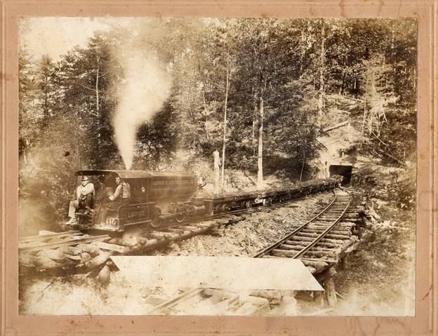
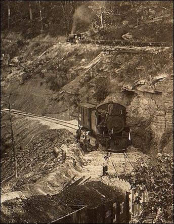
You’ve heard that a picture is worth a thousand words. This story involves three pictures, provided to Marv Clemons by one of the R&LHS Mid South Chapter members, [the late] Larry Kelpke. Three pictures and three captions on the back were all that there was to start solving a puzzle about coal mining and railroad history – an example like so many.
 |
 |
|
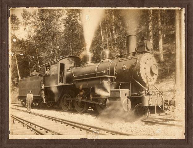
The caption of this wonderful image reads, "Louise" was a "dummy" that had no fire and was charged with steam from a power plant- thus, no fire in the mine. Samual [sic] T. Moss, Supt. Mine owned by Uncle Albert and son Everett. RR ran from Nyota to Warrior, about 10 miles circa. 1915.” |
The caption of the second image reads, “Owned by Uncle Albert and son Everett. #404 is probably an ex-L&N loco RR ran from Nyota to Warrior, a distance of about 10 miles. Also serviced the Sibleville [Sibleyville] Brick Co; Samual [sic] T. Moss Supt. of the mine. Circa 1915. Part of the Moss-McCormack Coal Co.” The caption doesn’t say that the lettering on the tender is “Warrior Mineral RR” |
We pretty well knew where Warrior was, on the “old” S&NA mainline. The author had heard of Nyota, and a search revealed it to be on the “new” mainline (c. 1915) of the L&N, somewhat to the east. The image shows that “Louise” bears the name “Warrior Black Creek Coal Co" (WBCCC). Research indicated that the WBCCC was active in the era of WWI and included members of the Moss family – quite a few of them in fact. There were three mines opened by the company, Liberty, No. 2 and Carbon. This was found in the Coal Directory of 1920, although the directory didn’t say a word about Louise, only referring to mule and rope haulage. These directories typically did say if the company owned any locomotives, but for reasons we don’t know, Louise didn’t make the directory. But we know she was there, cause we have pictures.
Now the story expands a little bit.
We have mention of the L&N
Railroad, the Moss-McCormack Coal
Company, and the Sibleyville Brick
Company. Both images give us a time frame
of 1915.
Research yielded the
Moss-McCormack Coal Company (MMCC) as a
successor to the WBCCC between 1920 and
1921 editions of the Coal Directory.
This series of Directories
covered the entire United States, and
was published by the Keystone Publishing
Co of Pittsburgh, and was found through
Google Books.
When
faced with research of this type, maps
are a key tool in the effort.
One source is the United States
Geological Survey, USGS, and these maps
are available free on line at the
“USGS Map Store” website.
For the Birmingham area, the
author knew that maps might be found in
three time frames, c. 1890, c. 1907 and
after that, sometimes the 1930’s and
sometimes the 1950’s and newer.
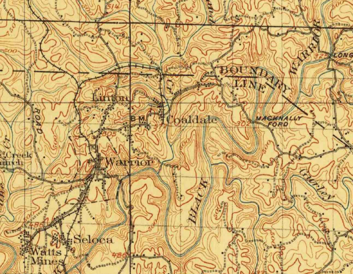
A wonderful map was found of the
area around Warrior, dated 1907.
This map image shows the
“old” S&NA/L&N mainline
through Warrior and shows two obvious
spurs to Watts Mines and to Coaldale.
The place name “Nyota” is not
shown on this map which indicates that
it was obscure or that it “hadn’t
happened yet” – one doesn’t always
know which.
But Nyota does show on the newer
USGS maps “sitting straddle” on the
“new” L&N mainline.
Nyota would be in toward the
upper right hand corner, toward the
“WA” in Warrior, above the “Y”
in Boundary (in the 1907 map below).
 |
 |
| US Geological Survey (USGS) map dated 1907. Found on USGS web site via Topo View. |
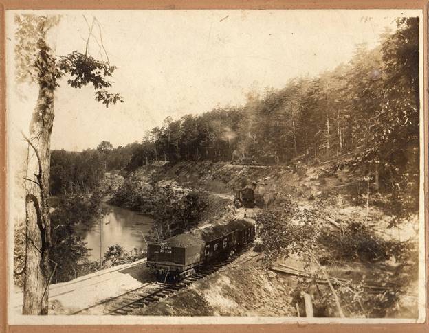
The caption reads, “Coal train of Moss-McCormack at Nyota, AL about 1914. Loco in background with a box car indicates some general merchandise hauling. Warrior River to left.” [Closer review makes this “boxcar” out to be a work car or a homemade caboose. |
“When in doubt, ask Google”, is another tool of the intrepid rail history “researcher” (nut). So, Google was asked about the “Warrior and Nyota” as well as the “Warrior Black Creek” coal company. The company name search results included a reference to the company incorporation charter, which in turn led to the Secretary of State’s online business records archive. Oh my, this website is a treasure trove of arcane data. For a $20 bill (credit card) the researcher downloaded documents from 1911 and 1912 about WBCCC which add much to our puzzle and the story behind it.
Milton Smith would have been proud! In fact he might have approved this business deal. The documents indicate that the WBCCC had a railroad called the Warrior Mineral RR. The Warrior Mineral desired to extend a spur to its parent’s new mine, but lacked the resources. The parent also lacked the resources, and so turned to the S&NA RR (Division of the L&N) for “aid”. Aid was forthcoming in the amount of $40,000 as well as “lend”-ing the railroad all the necessary hardware to build the line.
Of
more help was a solid location on this
venture.
First, contract document states
that track will be extended from the
Hogeland Br of the Linton Br of the
S&NA R.
From our 1907 map we can see
Hogeland Creek and we can see Linton, so
the names of the spurs make sense.
And the other location is “hard
stuff” – the “NW Qtr. of the NW
Qtr. of Section 8, Township 14S, Range 2
West”.
Without going into all the
details, this narrows the site down to
40 acres on the USGS map of 1907.
You just have to know how to read
the map.
And 40 acres is a pretty specific
area on a map of this scale.
This form of land reference is
called Range and Township and is used
throughout Alabama, which is a very good
thing for this type research.
The plot certainly began to thicken at this point. In looking at our 1907 map and the range & township location, this was nowhere near the Warrior River. Granted, it’s in the neighborhood, but we see no track alongside the Warrior River. What other maps might show this information?
|
|
|
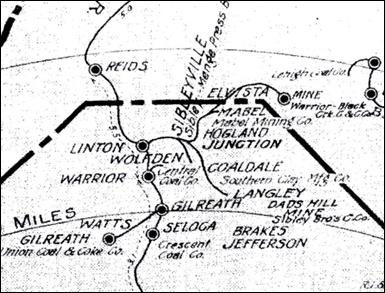
Segment from Kelly's 1905 "Mines, Railroads and Industries" map. |
The
Mid-South Chapter of the R&LHS sells
maps to its members as well as the
general public.
One of these is Kelly’s 1905
Mine, Railroad and Industrial Map.
It is a wonderful resource and
proved helpful in this puzzle.
This map doesn’t show “Nyota”
but it does show “Sibleyville” and
the brick company from caption two.
It shows Coaldale, and Hog[e]land
Junction, referred to in the railroad
loan contract and it shows a mine far
off to the right, labeled Warrior-Black
Creek Coal Company.
But is doesn’t show the river
– that is, this map doesn’t show any
rivers, so it is of no help there.
More
research was in order.
The author dug deep and realized
he had a mine directory downloaded
several years ago, dated 1986, that
ostensibly documents “every” coal
mine in Alabama with data on location,
ownership and mine name.
Skipping some details, this led
to a search of Blount County properties
of the Moss-McCormack Coal Company,
labeled “Upper Creek” with range
& township locations.
When these were plotted, low and
behold, they were close to the Warrior
River!
They were also close to the “mine”
shown on Kelly’s map labeled for the
WBCCC.
Another
resource collected by the author are a
series of aerial photos taken in 1940-41
by the Soil Conservation Service (SCS),
now a component of the Natural Resources
Conservation Service (NCRS).
But the collection only covers
Jefferson County, and a little bit over
the line.
Would there be any coverage?
Fortunately, the answer was “yes”
and it was exactly the coverage needed.
This
image is dated 2/17/1941 and shows a
large coal mining property, as indicated
by the many workers houses and telltale
shape of spoils piles.
The line running up and down the
picture (north-south) is the “new”
L&N mainline.
If you look closely you may be
able to see a “wye” track near the
top to the right of the mainline.
That is the location designated
“Nyota” on modern USGS maps.
What
is more important is the line in the
trees coming in from the left, and going
just above the bend in the river, in the
middle of the picture.
This line is a rail spur, and it
is “next to the Warrior River” just
as shown in picture number 3!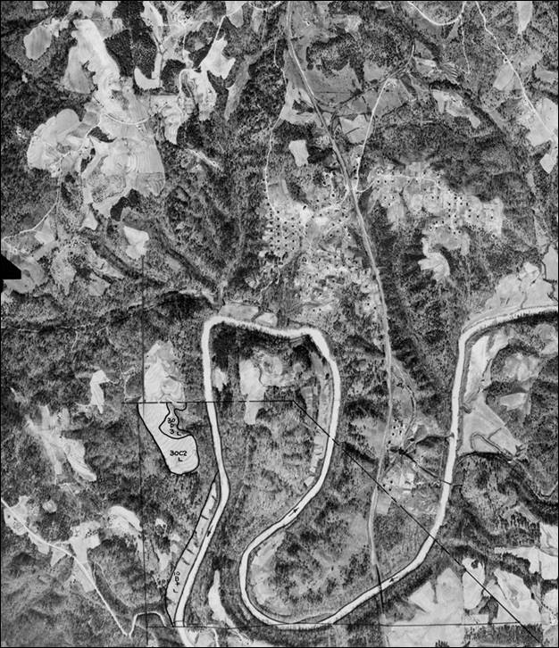
A
detail from image three shows the
“Louise” in the background on a
tramway on the bluff. There seems to be
a semblance of a coal dump (slide) to
enable the tramcars to dump from the
bluff to the hoppers or gondolas below
on the spur.
Putting
all the pieces of the puzzle together,
confirms that the rail spur for which
the company borrowed $40,000 from the
S&NA/L&N extended from the
Linton Spur to Nyota and it does end up
next to the river as shown in the image.
By the time of the 1941 aerial it
is pretty clear that the rail spur was
likely abandoned.
And why not – the main line of
the Old Reliable ran right through the
middle of the mines at Nyota!
So,
what became of the spur when the
mainline was relocated?
Kincaid Herr, in his landmark
L&N History tells us that this work
was done around Birmingham between
 1911
and 1914.
And the line from New Castle to
Bangor, which required the 2,200 foot
Hayden Tunnel, was “completed by
November 15, 1914.”
It certainly appears that image
three, dated 1914 is a brand new line,
freshly graded and ballasted, recently
cut trees and blasted rock in evidence.
So, did the coal company borrow
$40,000 only to complete the line in
time for the L&N to relocate the
mainline right through the area served
by the mortgaged spur track?
Did the L&N do the mine
company dirty?
Did the spur get some use to
amortize it before being abandoned?
1911
and 1914.
And the line from New Castle to
Bangor, which required the 2,200 foot
Hayden Tunnel, was “completed by
November 15, 1914.”
It certainly appears that image
three, dated 1914 is a brand new line,
freshly graded and ballasted, recently
cut trees and blasted rock in evidence.
So, did the coal company borrow
$40,000 only to complete the line in
time for the L&N to relocate the
mainline right through the area served
by the mortgaged spur track?
Did the L&N do the mine
company dirty?
Did the spur get some use to
amortize it before being abandoned?
We
don’t know at this point in our puzzle
solving.
Staring at the 1941 (right) aerial there
appears to be a mine tipple served by
the tramway “Louise” that would not
have been readily accessible to the
L&N mainline.
And there appears to be a formal
tipple from the tramway to the spur
track – maybe!
A field trip to the woods might
help tell the tale.
More research may help explain
the timing of improvements at Nyota.
But
the L&N did relocated some 25 miles
of mainline, serving Warrior for some
more years from the south by connecting
another old mine spur to the new
mainline.
Eventually the spur to Warrior
from the south was abandoned.
And what of the old mainline to the north of Warrior? It was abandoned in 1914 and some years later the Highway Department built a road on the roadbed. That road is US-31 which is the address of the Top Hat Bar-B-Que next to Blount Springs in Hayden, AL. Now, the Top Hat didn’t open till 1967. So, maybe the old Pit Man wasn’t hearing things, all alone, in the early hours, after all. What do you think? Could we still hear it 100 years later?
|
|
|
|
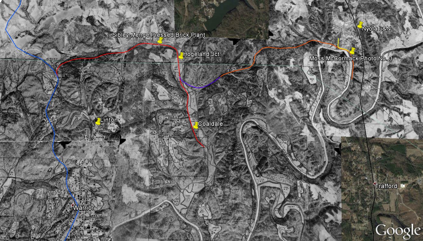
Google Earth overlay showing "old" L&N main line in blue, spur tracks to various industries and mines in red. The purple segment is thought to be the original spur to the Mabel mines, Mabel Mining Company shown on Kelly's 1905 map. The "Louise" tramway is shown in yellow. |
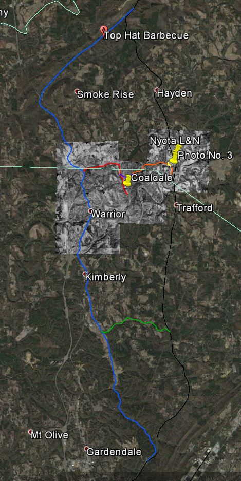
Larger view showing "old" L&N main in blue and "new" L&N main in black. |