L&N Relocation: Two Tracks or Not Two Tracks
 |
|
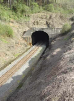
Brocks Gap Tunnel, 2004 |
 |
|
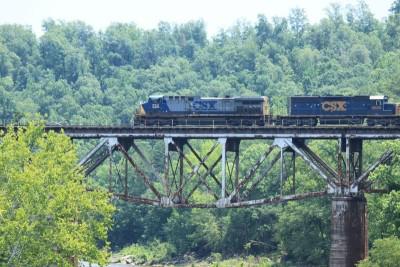
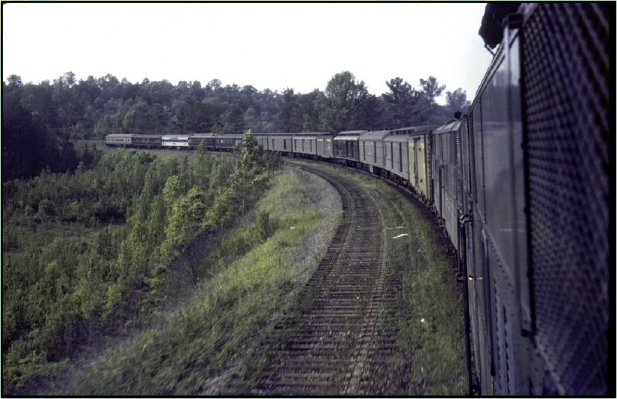
CSX train crossing the Mulberry Fork Warrior River [Photo https://bridgehunter.com/al/cullman/bh48984/}River
|
This material was originally prepared by the author for the Mid South Chapter R&LHS Newsletter, the Flyer. The author would like to acknowledge the help of the late Lyle Key as well as Thomas Denney and editor Marv Clemons who provided information and graphics from their collections. Due to space constraints in The Flyer, additional graphics and narrative are included here which were not able to be included in The Flyer.
f
you are a student of Birmingham’s
history you know that it was founded at
the junction of two railroads to be a
New South Industrial City.
And you likely know that in
post-civil war Alabama, there was
precious little capital for the building
of railroads in 1870.
The S&NA had been saved from
bankruptcy only by the efforts of James
Sloss’ Nashville and Decatur RR
(N&D) being offered, along with the
unfinished S&NA to the L&N RR in
a long term lease including the
requirement that the L&N complete
the railroad through the hills and
valleys of north Alabama.
According
to Chief Engineer John Milner’s son,
as noted in Armes “Story of Iron and
Coal in Alabama”, Milner would direct
the layout of the line north of
Birmingham to have “more curves, more
curves and more stiff grade”, in order
to save money.
Milner’s wife is quoted in the
same story as saying “that was not the
way my husband planned it, nor the way
he wanted it.
It was the way he just had to
make it.”
The Need for Improvements
Birmingham
did grow and prosper to the point that
the original line was inadequate.
In 1907, L&N President Milton
Smith addressed a committee of the
Alabama legislature describing the
situation in which the L&N
Railroad’s South & North Alabama
Subdivision found itself.
This address was part of an
ongoing battle royal between the L&N
and the Alabama Legislature over rates,
but that is another story. Smith stated,
“Take the North and South
Alabama as an illustration.
It is a road originally built
with limited capital through a rugged
country across drainage, and when opened
for traffic there was not a community of
100 persons on the line between
Montgomery and Decatur.
The Alignment is crooked and the
grades excessive, equivalent to more
than 80 feet to the mile [1.5%].
The heaviest locomotive in use,
having a tractive power of 35,000 lbs.
can move but 740 train tons.”
 |
 |
 |
|
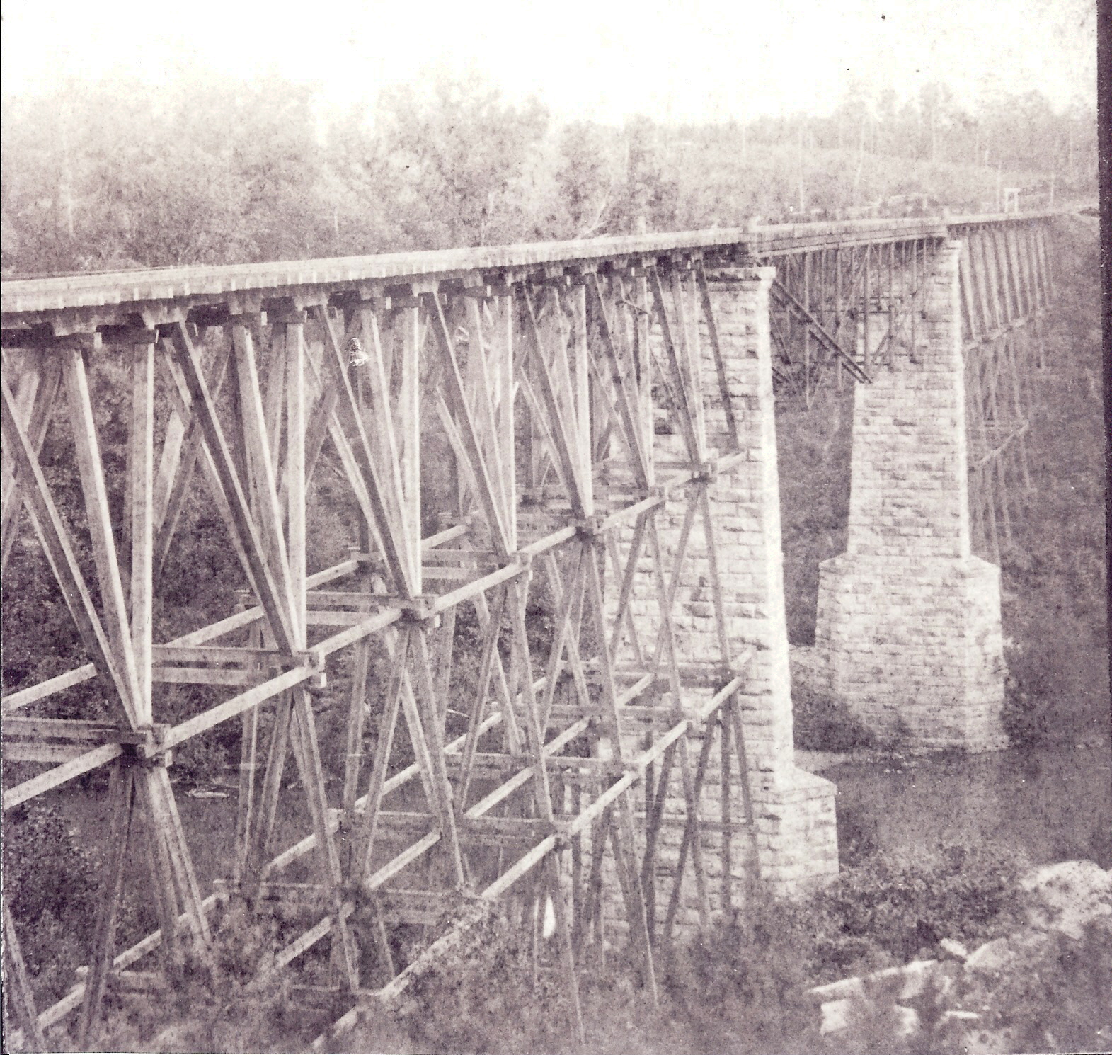
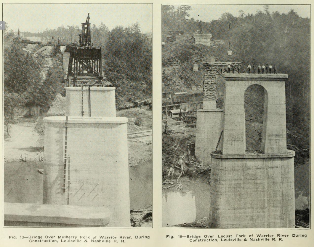
This is believed to be the original S&NA bridge over the Locust Fork near Warrior, AL. Note the approach spans are wooden and the main span is a Fink Truss. The piers appear to be the same as the image on the right, except caps. The piers are still standing, c. 2020. Image from Jim Bennett collection. |
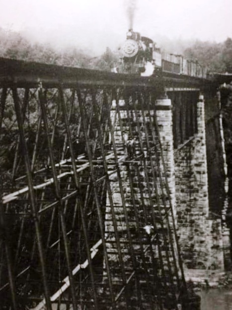
This is believed to be the rebuilt bridge over the Locust Fork. Here the approach spans appear to be an iron trestle work, and the main span is a heavier deck truss. Image from Warrior, AL Facebook page. |
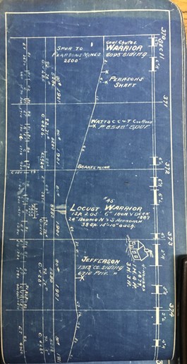
1895 Track Chart from Ken Penhale notes that the bridge was rebuilt in 1887 with a "205', 6" Iron V Deck and 24" beams N&S Approach, 38 spans 15'-10" each". |
Smith’s
point was to seek to have the
legislators understand that railroads
must be able to respond to traffic
demands if they are able to support
shipper’s needs and that improvements
cost money.
By
the time that Milton Smith was before
the legislative committee in Montgomery,
the L&N had already double tracked
14 miles
through Birmingham from Black
Creek south to Oxmoor. Most of this work
was done near original location with
moderate adjustments in alignment and
curvature.
Likewise work had been done from
Decatur south to Flint about 5 miles in
north Alabama, and from Calera south to
Hardy [near Alabaster] about 13 miles
providing double track, passing sidings
and terminal facilities as reported in
the Railroad Gazette.
This included old Boyles Yard
opened in 1904.
Smith outlined these recent improvements to the legislators but stated,
“traffic now pressing is greater than can be moved and if the present volume of traffic is to be continued and increased, it will be necessary to reconstruct the line, reduce grades and curvature, lay second tracks… the work of reducing grades and laying second track between Oxmoor and [Alabaster], 14.4 miles has been begun at an estimated cost of $1 million.”
Smith
went on to say that the other needed
improvements between Montgomery and
Decatur would cost $15 million. Smith
finished by saying that if capital could
not be obtained “the carrier must
restrict its traffic to existing
facilities, that is, must refuse to
undertake to move traffic in excess of
its facilities.”
Birmingham’s growth would stop.
Of
interest from an engineering standpoint
is what and how the improvements were
made.
Fortunately the railroad press of
the day has provided great information.
The
project mentioned above, between Oxmoor
and Hardy [near Alabaster] included a
new crossing of the Cahaba River and
Shades Mountain.
The old line had been completed
before the Civil War to the south foot
of Shades Mountain at Sydenton; the 75
foot deep cut through the mountain was
not completed until about 1870.
The new line was completed in
1908 and involved relocating the
mainline, a new bridge over the river
and a tunnel at lower grades through
Shades Mountain to replace the deep cut
[now mostly filled in]. This project is
covered in this website under the
heading of Brocks
Gap, Gateway to Birmingham.
It is noted above that improvements had been completed from Black Creek south through Birmingham to Oxmoor. Black Creek is north of Boyles Yard and near New Castle, John Milner’s coal development built to assist the fledgling S&NA to develop new traffic. From New Castle northward the original line swung to the northwest along Cunningham Creek and passed through some of the earliest coal mining areas of Birmingham at Morris and Warrior, crossing the Locust Fork of the Warrior River and traversing valleys and Reid's Gap to gain ground over the ridges, crossing the Mulberry Fork of the Warrior River toward Cullman.
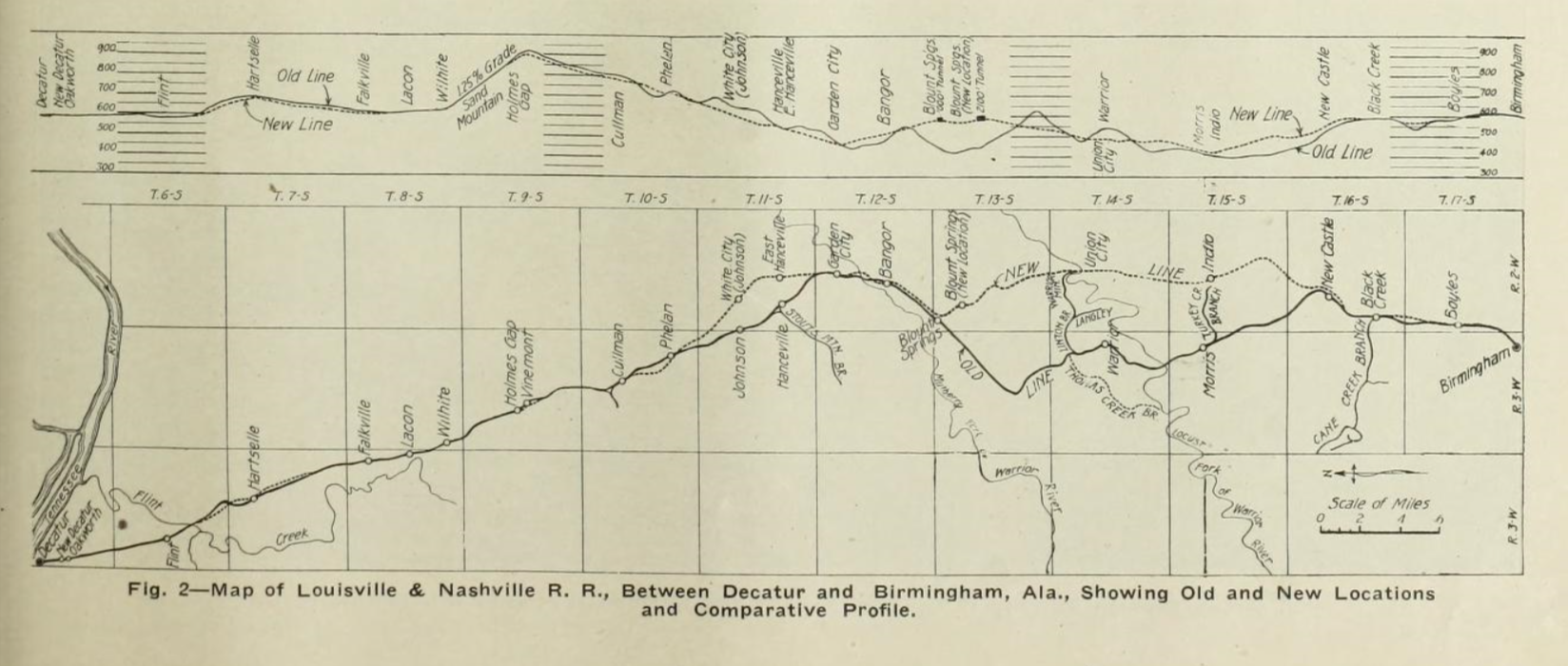 |
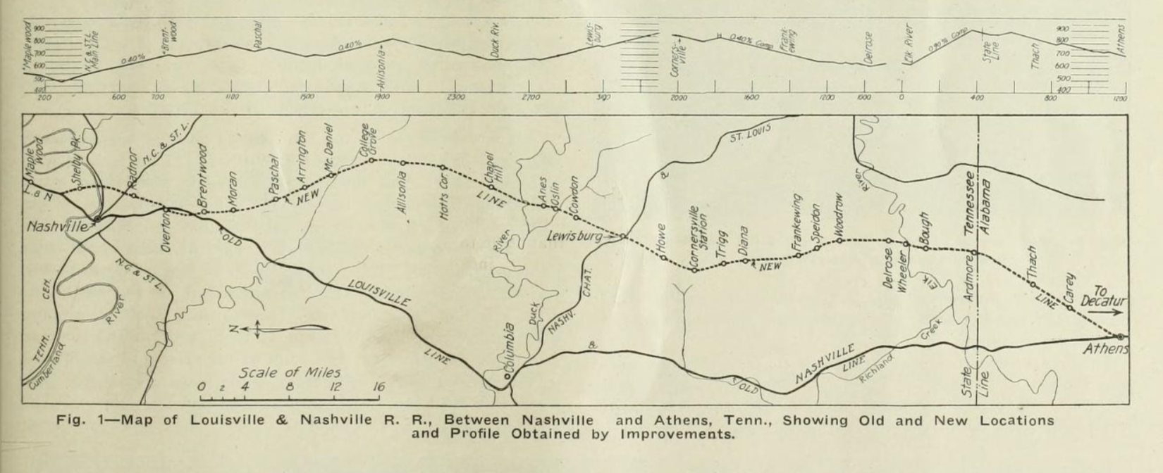
| The relocation and grade revisions are shown in this image for an article in Railway Review magazine May 9, 1914. Note the 1.25% Sand Mountain grade which is still a helper district today. There are two river bridges and two tunnels. |
It is in this area that the L&N completed one of the most ambitious improvements between Birmingham and Decatur. This was part of a larger “grade revision” project that extended from just north of Nashville, TN, south to Decatur, and then on south through Birmingham to Calera.
 Athens
to Decatur
Athens
to Decatur
From
Athens to Decatur the line was
relatively flat but on swampy terrain
near the Tennessee River.
Bids received were higher than
the L&N wanted to pay, so this line
was built by company forces.
Equipment was acquired for
$85,000 which included a self-propelled
Atlantic Steam Shovel, 10 air operated
dump cars, a modified tender to serve
the shovel and provide a workshop
platform, an all steel Bucyrus pile
driver, a Jordan spreader, and a caboose
workshop car.
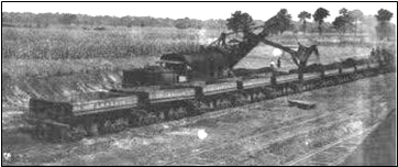
This work train used small locomotives to shuttle the dump cars as required. The Atlantic shovel was self-propelled and equipped with air brakes. According to “The Excavating Engineer” this outfit was very successful and saved enough money compared to bids received to pay for the equipment. The picture at right is from the Excavating Engineer, April, 1914. The total excavation on this line segment was 385,000 cubic yards at the “Tanner cut” which was then used to build new fill on the swamp areas north of the Tennessee River.
The
L&N didn’t have a bridge over the
Tennessee River at Decatur; L&N [then
and now] had trackage rights over the
[Norfolk] Southern’s bridge.
The new line improved the bridge
approach location on the north side of
the river for L&N. On the
south side of the Tennessee River,
L&N had already built extensive
facilities at New Decatur, south of
Decatur including yards and shops. South
of Decatur for the first 20 miles the
work was not remarkable.
It did improve grades and
alignment to
some degree.
If
you drive I-65 frequently, north of the
Lacon exit, you may have noticed a
siding in the trees on the east side of
the interstate that often holds a
locomotive.
This is the pusher for the
controlling southbound grade on the
L&N at Sand Mountain from Wilhoite
to Holmes Gap..
The grade was and is 1.25%; civil
engineers at the time couldn’t find a
way to avoid it.
The SB
pusher grade up the mountain is
about 5 miles long.
On
the south side of the mountain, the
northbound grade is about 12 miles, but
at a more manageable grade of 0.5%. The
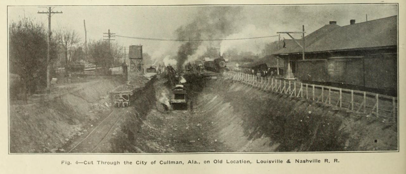
town of Cullman is located on this
segment of line.
Here the L&N decided to lower
the old line some 20 feet right through
town.
This required staged
construction, relocation of the station
and freight house and the construction
of 5 street overpasses.
These 5 overpasses were reinforced concrete with sidewalks on each side. The loading was designed for a 35,000 lb. road roller plus 100 lb. per square foot. Today 3 of the original bridges over the railroad are still in use, but are posted at 10 Ton total weight, including school buses. [Note that a full size school bus weighs about 16 tons empty!] These overpasses are still standing in 2020.
Cullman
to Birmingham
South
of Cullman there were significant
engineering issues to be addressed.
Most of the old line from Cullman
to Birmingham was relocated to a
completely new alignment.
Much of the remaining line was
changed vertically so that for practical
purposes, it was all new line.
The
primary obstacles were the ridges at
Blount Mountain and Hayden, the climb to
these ridges and the major water
crossings at Mulberry Fork and Locust
Fork of the Black Warrior River as well
as the crossing of Gurley Creek.
In addition there were many
smaller streams and creeks to cross.
It
is worthy of note that when the original
line of the South & North Alabama
was planned in the 1850’s, it was
determined that it would be a line
crossing ridge and valley terrain.
The mineral wealth of this
district was well known and Chief
Engineer John Milner knew that the
original investment for the main line
would be great, but that the extension
of spurs and branch lines to the future
mines would be easier to build when the
time came.
The original competitor of the
South & North, the Alabama &
Tennessee River connected Meridian MS
with Chattanooga and followed a much
easier valley route for much of it’s
length.
As it turned out, that line,
which became the Alabama Great Southern
did not achieve nearly the raw material
traffic from the mines of the Birmingham
District as the L&N.
The
new line and grade was planned to climb
the side of Blount Mountain, heading
southwest.
This line followed the original
line but at higher elevation to ascend
the “mountain”.
After climbing the line turned
south and two tunnels were bored.
The first, Blount Mountain, is
about 1000 feet long and is unlined,
being in good rock.
The tunnel was built from the
bottom up, that is, the boring started
at the track level and worked upward as
forward progress was made.
The
second tunnel, at Hayden, is about 2100
feet long but was in less sound rock and
had to be concrete lined.
It was built from near the top
and then excavated down to the floor as
forward progress was made.
The roof was lined and then then
as work progressed downward the sides
are cut and lined; the upper portion has
a footing behind the top of the side
walls.
The south end of the Hayden
tunnel encountered such poor rock that
the portal was built about 150 feet into
daylight, the tunnel constructed and
then filled to prevent slides from
coming over the top of the portal.
It
is interesting to note that compressed
air was used for drilling equipment and
that the contractor had an air
compressor plant on the old line, using
iron pipe to take the compressed air to
Blount tunnel and then on to Hayden, a
total distance of about 3 miles.
South of Hayden tunnel, the line followed a ravine and stream bed going downhill towards the south. The tunnel material was used to build a long fill coming down the south side of the mountain.
River
Crossings
 |
||
 |
 |
|
 |
||
The
three major water crossings mentioned
above are still standing.
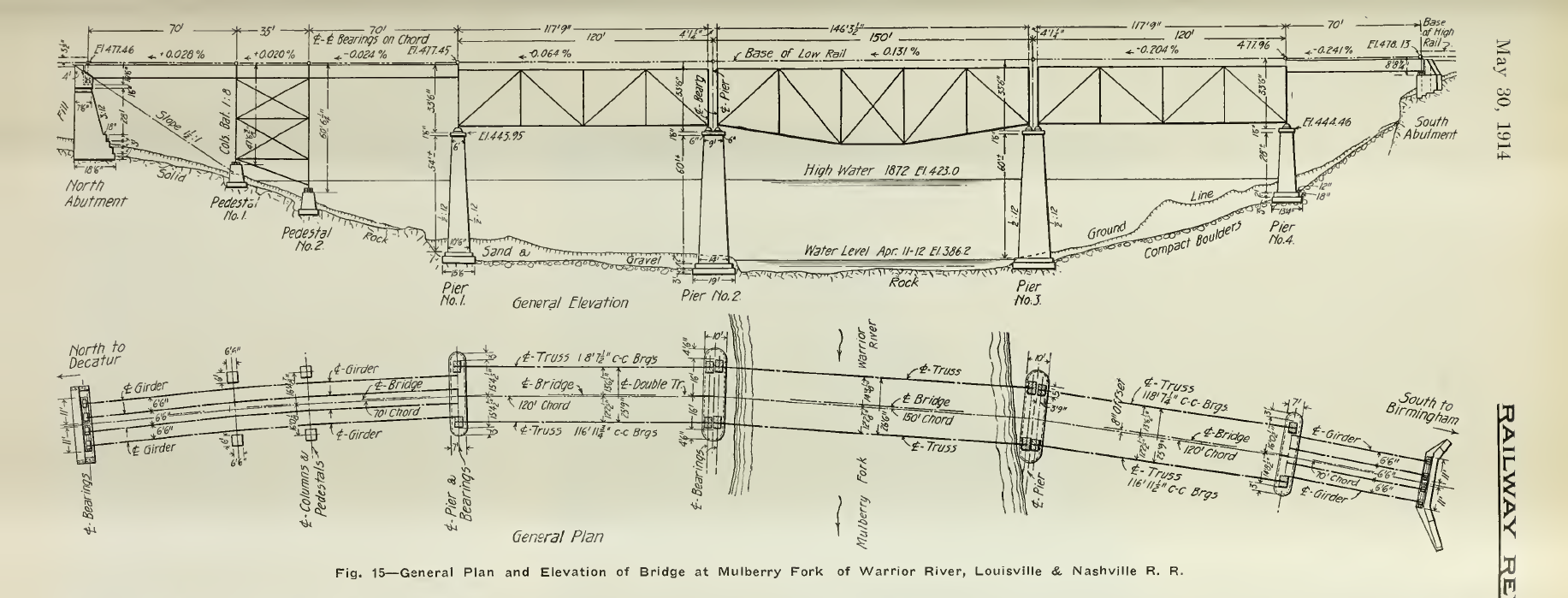
The Mulberry Fork bridge is north
of the two tunnels described above.
It consists of three girder
spans, three deck truss spans and a
girder span, all open deck and all on a
3o
curve.
The spans are
70’-35’-70’-118’-146’-118-70’
(rounded).
The concrete piers for the truss
spans are about 60 feet tall.
This handsome bridge is visible
from the old highway looking east, and
has a curved lower cord on the main
truss span.
[Photo is from https://bridgehunter.com/al/cullman/bh48984/}
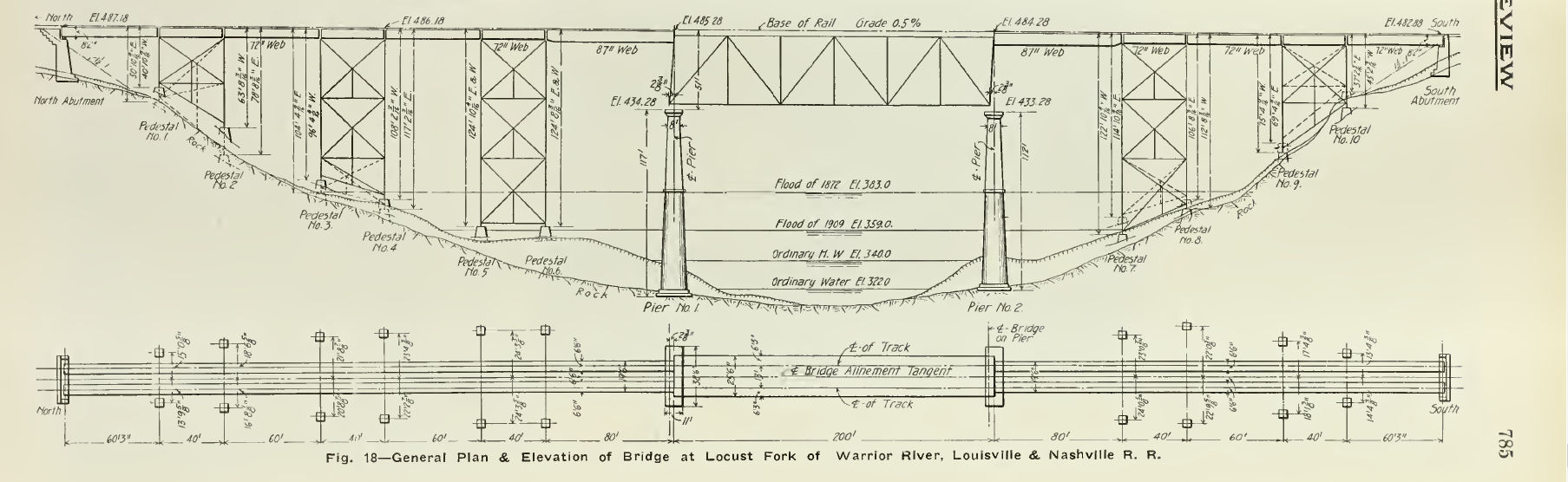
The
Locust Fork bridge is on tangent
alignment and is also a combination of
one deck truss span with deck girder and
tower approaches.
The span arrangements are
60’-40’-60’-40’-60’-40’-80’-200’-80’-40’-60’-40’-60’
(rounded).
The concrete piers for the truss
span are about 115’ tall.
The
third major structure on the relocated
route is at Gurley Creek.
This is a tower trestle structure
with 7 plate girder spans and 6 @ 40’
tower spans.
The
span arrangements are
70’-40’-60’-40’-60’-40’-60’-40’-60’-40’-60’-40’-70’
for a total length of 680 feet.
A
number of concrete arch spans were
constructed as part of this project;
concrete had certainly come into its own
by this time period.
Earlier structures would have
been constructed of cut stone masonry,
including arches.
These may be found on the
original routes of the S&NA as well
as the N&D, as well as stacked stone
box structures.
The Ross Bridge stone arch
culvert in Hoover, AL, has become
“famous”.
These improvements were completed by the time the United States entered WWI. Railroad operations continued through the twenties and lanquished through the depression years. Then the onset of WWII brought growth in traffic and industrial development.
Improvements
in Tennessee
Briefly,
the project in Tennessee included a new
line to bypass Nashville, cross the
Cumberland River on a major high bridge
which still stands above Shelby Park,
build Radnor Yards north of Brentwood
[south of Nashville], and a new grade at
present day Brentwood which lowered the
line 45 feet, and may still be seen
adjacent to the Brentwood interchange on
I-65.
From Brentwood the L&N built a new route 98 miles south to Athens, AL. This “new line” would supplement the original Nashville & Decatur RR (N&D) built before the Civil War by James Sloss. The new line included two tunnels and a pusher district of 0.9% for some 6 miles. The new line was planned for freight traffic so the old N&D line could be used for mostly passenger traffic and local freight. This effectively created a double track line from Nashville to Athens although on separate locations some mile apart.
 |
|
The relocation and grade revisions are shown in this image for an article in Railway Review magazine May 9, 1914. The "old" line was the original Nashville & Decatur built for James Sloss before the Civil War. |
CTC and Back to Single Track
|
Seeking new operating efficiencies, the L&N implemented Centralized Train Control (CTC) which involves the use of electro-mechanical systems to enable one operator to control signals and track switches (turnouts) on a large segment of railroad. According
to Murray Klein’s “The
History of the Louisville &
Nashville Railroad”, the
L&N’s first CTC
installation was the 96 miles
between Brentwood, TN, south of
Radnor Yards near Nashville to
Athens, AL..
This improvement was
accomplished in June, 1942.
Subsequent installations
focused on single track lines,
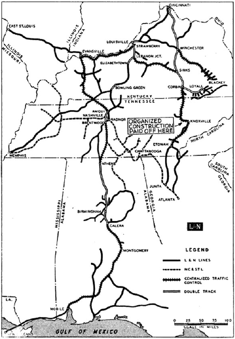
as shown on this 1956 map from
Railway Signaling magazine. Typically,
installation of CTC on single
track lines enabled fewer
passing sidings, fewer block and
siding signals, and less
operating and maintenance staff.
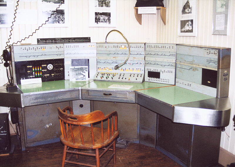
The image at left shows a
CTC panel at Birmingham.
This display is located at the
Heart of Dixie RR Museum in
Calera, AL, south of metro
Birmingham. The double track between Athens and Calera in Alabama was one of the last segments to receive CTC. As was typical, the efficiencies of CTC enabled the railroad to remove double track, and this was accomplished by 1963 (Klein) when the entire mainline from Cincinnati to New Orleans was under CTC control. Ironically, when CTC was finally installed between Athens and Calera, the need for the double track main line was eliminated. Once the CTC system was in place and working, the railroad began removing the second track installed between 1908 and 1915. In the image at the lower left, from Marv Clemons' collection, we see the results of the removal of double track south of Calera, AL, after the installation of CTC. |
 |
|
 |
 |
|